

Quick answer
Mount Rinjani trekking route options include the Senaru trail (10 km to rim, forested approach with gradual ascent), the Sembalun trail (8.5 km to rim, open savanna with steep final push), and the Torean trail (southern approach, least trafficked, moderate gradient). All three routes converge at the crater rim before the summit scramble. Registration and permits are processed at park gates between 08:00–10:00 before afternoon weather deteriorates.
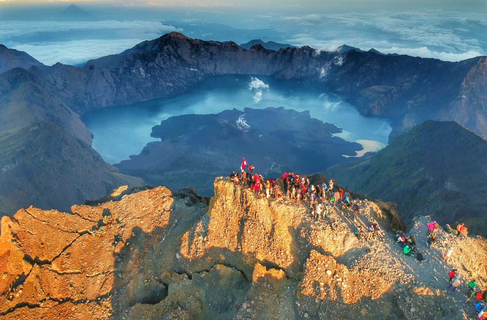
The volcanic cone of Mount Rinjani rises 3,726 meters above Lombok, and three distinct paths lead trekkers from lowland villages to the caldera rim at 2,639 meters. Each mount rinjani trekking route reflects the geography of its starting point—northern rainforest, eastern grassland, or southern foothills—and carries implications for acclimatization, shelter availability, and trail traffic. The Senaru trail departs from 601 meters elevation and winds through dense montane forest for the first six kilometers, crossing the Pos I and Pos II shelter stations before breaking into subalpine scrub. The canopy moderates temperature in the lower sections, and water sources remain accessible until Pos III at 2,000 meters. Trekkers cover roughly 10 kilometers horizontal distance to reach the rim, gaining 2,038 meters vertically over terrain that alternates between rooted switchbacks and volcanic scree. The Sembalun route begins at 1,156 meters on the mountain's drier eastern flank, traversing open savanna and grass slopes that offer unobstructed views of the caldera and minimal shade. The trail measures 8.5 kilometers to the rim but compresses the final 700-meter ascent into a relentless grade above Pos III, where altitude effects become pronounced. Summit attempts typically launch from Sembalun Crater Rim Camp at 2,639 meters in the pre-dawn hours. The Torean trail, accessed from the village of Torean on the southern slope, sees the least foot traffic and lacks the permanent shelter infrastructure of the northern and eastern routes. The path climbs steadily through secondary forest and agricultural terraces before entering the national park boundary, eventually merging with trails from the other trailheads near the rim. Navigation on the Torean route requires local guide support, as waymarking is less established than on Senaru or Sembalun paths. Multi-day treks often combine routes—ascending via Sembalun for altitude gain efficiency and descending through Senaru's shaded forest to ease knee strain on the lower sections. The crater lake, Segara Anak, sits 600 meters below the rim and can be reached via steep descents from any of the three primary routes, though that detour adds significant elevation loss and regain to any trekking itinerary.
“The canopy moderates temperature in the lower sections of the Senaru trail, while the Sembalun route compresses the final ascent into a relentless grade above 2,000 meters.”
Mount Rinjani Trekking Route: Senaru vs Sembalun vs Torean
Readers planning a Mount Rinjani trek face a real choice between three trailheads — Senaru, Sembalun, and Torean — that differ in distance, terrain, and typical direction of travel, and picking the wrong one changes the whole itinerary.
|
Top pick Senaru North route, standard ascent |
Sembalun East route, common descent or alternate ascent | Torean East route, steep and less-maintained | |
|---|---|---|---|
| Starting village | Senaru village, North Lombok | Sembalun village, East Lombok | Torean village, near Sembalun |
| Distance to rim/summit | about 8.5 km to crater rim (Pos 3) | about 9 km to Pelawangan Sembalun rim camp | no direct summit access, connects to crater lake basin |
| Difficulty | steep forest trail with switchbacks | long exposed savanna approach, gradual then steep final push | technically demanding, narrow ridge sections and river crossings |
| Typical direction (ascent/descent) | primary ascent route | primary descent route, sometimes ascent | rarely used for summit, mainly crater lake or hot springs access |
| Scenery highlights | montane rainforest, Segara Anak crater lake views from rim | savanna grassland, Sembalun valley panoramas | crater lake close-up views, Torean waterfall, hot springs |
| Crowd level | highest, most trekkers start here | moderate, common for loop itineraries | low, used by a small share of trekkers |
Verdict: Trekkers on a standard 2-3 day loop typically ascend via Senaru and descend via Sembalun, while Torean suits experienced hikers seeking a quieter route to the crater lake and hot springs rather than the summit.
Mount Rinjani Trekking Route Itineraries by Day Count
Three itinerary structures serve different fitness levels and summit goals. The 2D1N option reaches the crater rim, while 3D2N and 4D3N plans add summit attempts and lake access.
Senaru to Pos 2 or Sembalun Start
2D1N treks begin at Senaru trailhead (1,156 m) and climb through rainforest to Pos 2 camp (2,200 m) in 6–7 hours. 3D2N and 4D3N typically start from Sembalun gate (1,156 m), ascending open grassland to Sembalun Crater Rim camp (2,639 m) in 7–8 hours.
Crater Rim or Summit Push
2D1N groups descend from Pos 2 via Senaru (5–6 hours). 3D2N itineraries summit pre-dawn from Sembalun Crater Rim (3–4 hours up, 2 hours down to rim), then descend to Senaru via Pos 2. 4D3N plans mirror the summit but camp at Segara Anak lake (2,000 m) after.
Lake Activities or Senaru Descent
4D3N itineraries spend the morning at Segara Anak—hot springs accessible in 30 minutes from camp—then climb back to crater rim (3 hours) and camp at Pos 2 or descend partially.
Final Descent via Senaru
4D3N groups complete the Senaru descent (4–5 hours) through montane forest to the gate. Porters typically depart camp by 07:00 to avoid afternoon rain on lower slopes.
Getting to the Mount Rinjani Trekking Route Trailheads
Mount Rinjani National Park sits in northern Lombok, and all three trailhead villages are reached overland from Lombok International Airport (Zainuddin Abdul Madjid Airport, Praya) since the park has no rail or metro access. Senaru and Sembalun are the most commonly reached, with Torean requiring an extra leg through Sembalun or Senaru.
Airport to Senaru via Mataram–Bayan road (Jalan Raya Bayan)
Airport to Sembalun via Mataram–Pusuk Pass–Aikmel road
Public bemo/minibus Mataram (Mandalika terminal) to Bayan, then local transport to Senaru
Airport to Senaru or Sembalun, metered or pre-booked
Sembalun or Senaru to Torean village (unpaved final stretch)
Best Time to Hike the Mount Rinjani Trekking Route
The dry season from April through November is the only period Mount Rinjani National Park permits trekking, since heavy rain and lightning risk force a seasonal closure roughly from January through March. Within that window, arriving at the registration post between 08:00 and 10:00 keeps permit processing ahead of afternoon cloud buildup on the crater rim.
July-August
Peak crowds, book trailhead transport earlyDriest, coolest, 15-20C at rim, colder at night
These are the most stable weeks for summit visibility, with the lowest chance of afternoon rain interrupting the Senaru or Sembalun ascent.
April-June and September-November
Moderate, fewer groups on trailWarm days, occasional short showers, 18-24C lowland
Shoulder months still fall inside the open season and offer a calmer trail with a small risk of brief rain rather than sustained storms.
January-March (closed)
Not applicable, park closed to trekkersHeavy monsoon rain, frequent lightning
The park closes for trekking during peak wet season due to landslide and flooding risk on all routes, including Torean.
Daily arrival, 08:00-10:00
Thinner queues at the registration post—
Reaching the post in this window gets permits processed before afternoon rain and cloud buildup, which matters most on the more exposed, technical Torean route.
Verdict: July or August, arriving at the registration post between 08:00 and 10:00, gives the most stable weather and smoothest permit processing across all three routes.
Preparation Checklist for the Mount Rinjani Trekking Route
Multi-day treks above 3,000 meters require advance logistics and specialized gear that general tourism doesn't cover.
-
Book a licensed guide and porter package — Indonesian law prohibits independent trekking in Mount Rinjani National Park—all visitors must trek with registered operators.
-
Secure your permit 7–14 days ahead — The park office processes trekking permits by route and date, with daily quota limits during peak season.
-
Withdraw sufficient cash in Mataram or Senggigi — The 150,000 IDR conservation fee and most trailhead services accept rupiah only—no card terminals operate at registration posts.
-
Pack a four-season sleeping bag rated to -5°C — Summit attempts between 02:00–05:00 face freezing temperatures and wind chill that synthetic bags cannot handle.
-
Bring two water bottles (3+ liters capacity) — Natural water sources exist on-trail, but the volcanic scree sections between Sembalun Crater Rim and the summit offer no refill points for 4–5 hours.
-
Load offline maps for your chosen route — Mobile signal drops after the first hour on all three trails—GPS track files prevent wrong turns at unmarked junctions near the crater rim.
Common Mistakes When Choosing a Mount Rinjani Trekking Route
Route choice errors turn manageable treks into evacuations. Most failures stem from underestimating technical difficulty, skipping mandatory guide bookings, or choosing itineraries that miss the summit window.
Booking Senaru-only treks and missing the crater rim
Senaru trails end at the lake unless you book a summit extension. Confirm your itinerary includes the 3,726 m rim ascent if that's your goal.
Attempting Torean route without technical trekking experience
Torean involves exposed ridges and scrambling sections unsuitable for first-time trekkers. Choose Senaru or Sembalun if you lack multi-day mountain experience.
Arriving without a pre-booked licensed guide
Solo trekking is prohibited; rangers at trailheads turn away unaccompanied hikers. Book through registered operators 2–4 weeks ahead, especially June–August.
Skipping acclimatization camps on direct-summit itineraries
Sembalun's 2D/1N route climbs 2,000 m in 18 hours, causing altitude sickness in under-prepared trekkers. Add a rest day at Plawangan crater camp (2,639 m) if you're not acclimatized.
Choosing multi-day routes during January–March closure
The park closes for monsoon safety; permits are not issued. Trek April–December, with dry-season reliability May–October.
Underestimating descent time and missing return transport
Senaru descents take 5–6 hours; missing your booked pickup leaves you stranded in villages with limited onward options. Schedule vehicle pickup for 15:00 or later.
Check availability
FAQ: Mount Rinjani Trekking Route
Everything you need to know about mount rinjani trekking route